CRC TRR 228 Project Z02
Z02 Data Management and Services (INF)
Z02 Data Management and Services (INF)
Project Summary
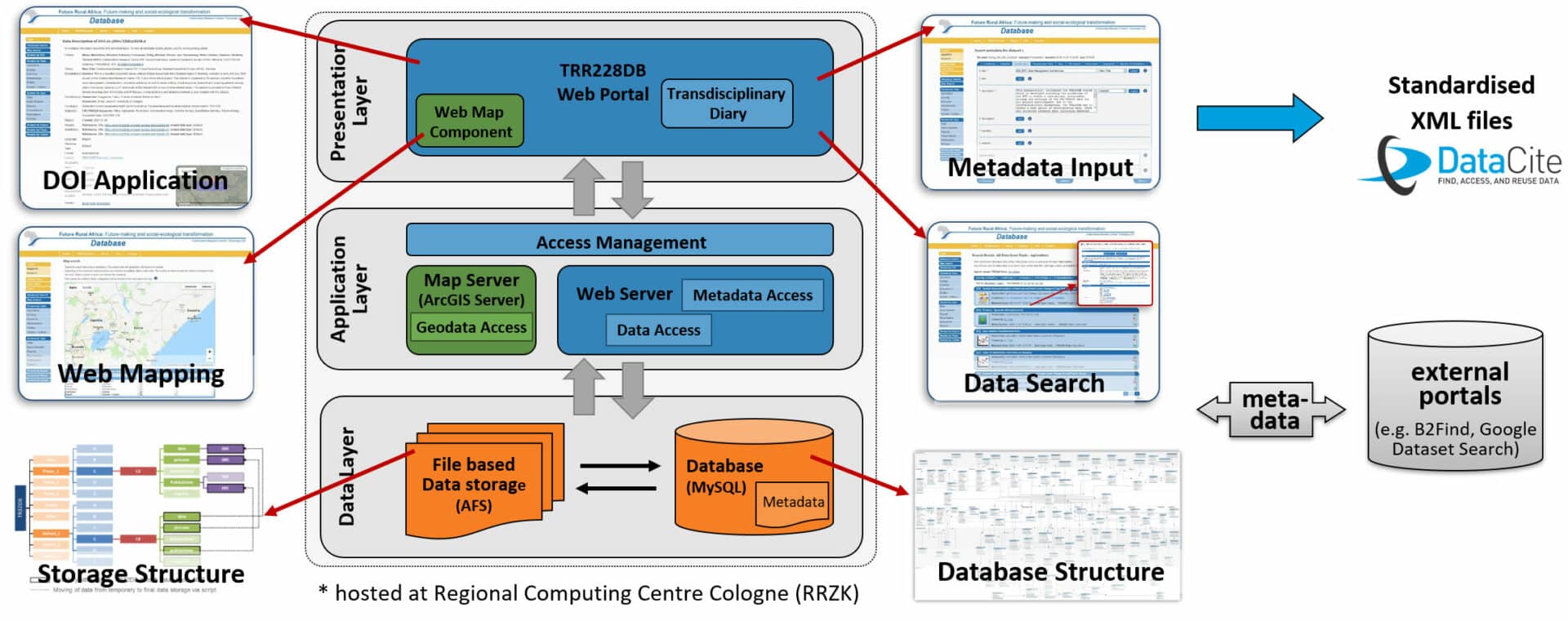
The management and sustainable provision of research data have been recognized as central tasks in interdisciplinary research efforts. During Phase 1, the service project Z02 (INF) successfully established a sustainable in-house developed and implemented research data management (RDM) infrastructure tailored to meet the requirements of the DFG and CRC. The TRR228 database/data repository (accessible online at www.trr228db.uni-koeln.de) ensures the secure, stable and multi-user operable long-term storage of all project-related data. Our project’s primary focus includes the continued maintenance and development of the TRR228 database system to align with evolving project requirements, as well as compliance with applicable standards and interfaces (e.g., ensuring metadata schema interoperability and DOI integration). Key activities also encompass ongoing RDM training and support for all project members. Additionally, we have focused our efforts in the second phase on updating and reprogramming several database features to more modern programming standards with the aim of improving the user experience and reduce technical issues.
Alongside our responsibilities in research data management, we contribute to various research projects by providing support in GIS and remote sensing data acquisition and analysis. We regularly acquire high-resolution satellite imagery for specific regions and gathered during phase 2 over 6 TB of PlanetScope imagery covering Kenya, Tanzania, and Namibia—the three main focus areas of CRC 228. Additionally, since phase 2, Z02 has concentrated on collecting historical topographic maps from various archives to create a comprehensive collection of historical data for Kenya and other focus areas of the CRC. With the aim to transform historical geographic information from these analogue maps into digitally usable formats, we have extracted in close cooperation with research project A05 the historical road network of Kenya from the 1950s to 1980s from more than 500 historical topographical maps. This dataset, openly available in the TRR228DB, represents the first highly detailed digital reconstruction of Kenya’s road network from that era. It offers valuable insights into past and current future-making infrastructure-related initiatives shaping Kenya’s development.
Problem Statement
Research data management (RDM) consists of all processes and measures to ensure research data is well organized, documented, preserved, stored, backed up, accessible, available and re-usable. RDM infrastructures can improve collaboration between scientists and link research results, and is crucial for developing synergies in large, long-term interdisciplinary research projects. Metadata is important to find, re-use, and understand research data. Technical and social problems might occur and can lead to data loss. Thus, intensive training and support, as well as incentives need to be implemented.
Relation to the CRC
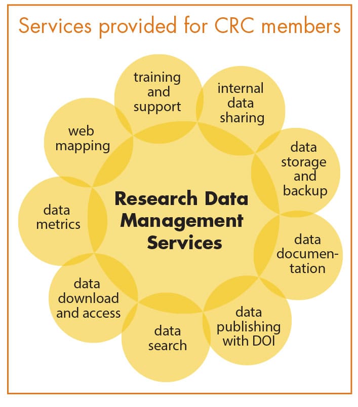
NF (Z02) has a central role within the CRC to continue the provision of RDM data services for storage, documentation, (re-)use and exchange of all relevant project data (e.g. quantitative and qualitative interview data, survey results, maps and GIS data) within the framework of our established TRR228 database/data repository. Additionally, RDM training workshops will be offered to all project members as well as GIS and remote sensing support to serve selected projects.
Work Plan & Methods
- Further maintenance, update and development of the TRR228 data repository
- Development of the ‘TRR228DB-Box’ to provide long-term accessibility of project data after funding
- Data management training and support for all CRC Members
- GIS and remote sensing support of other subprojects
- Geo- and satellite data aquisition to provide, process, analyse, and manage licenses for satellite data (e.g., Pléiades Neo, WorldView-3, Planet)
- Acquisition of further historical topographic maps from the mid-20th century for the study areas of the CRC to establish an encompassing collection of historic maps
- Land-use and land-cover analyses from current and historical remote sensing data for selected study areas.
Key Achievements from Phase II
- Successful update and reprogramming of several database features to more modern web standards that enhance user experience and reduce technical challenges. Significant updates were made to all aspects of data management, including uploading and downloading data, documenting data with metadata, user views, automatic backups, archiving, and applying TRR228DB-DOIs.
- Organization of regular trainings and support sessions for CRC members on data management topics and the handling of the database.
- Acquisition of high-resolution satellite imagery such as PlanetScope and Pleiades Neo. In addition, we gathered more than 6 TB of PlanetScope imagery covering the entirety of Kenya, Tanzania and Namibia.
- Collection of more than 500 historical topographical maps of Kenya from several archives in the UK and Kenya in collaboration with A02 and A05.
- Extraction of Kenya’s historical road network from the 1950s to 1980s using deep learning techniques in close co-operation with A05. This dataset stands as the first highly detailed digital representation of Kenya’s road network from that era and is openly accessible in the TRR228DB. The successful application of deep learning methods transformed geographic information from analogue maps into digitally usable formats, making them valuable for future research.
Key Achievements from Phase I
1. Online survey on demands and needs of data management services among all CRC-TRR 228 project members
2. Successful establishment of the TRR228 database as a central data repository for all types of CRC228 project data. The database is accessible online at www.trr228db.uni-koeln.de since November 2018
3. Development of a project specific metadata schema to ensure a sufficient description of all types of project data from different scientific disciplines (Kramm and Curdt, 2020).
4. Establishment of a DOI application system for datasets in the TRR228DB.
5. Organization of regular trainings and workshops on data management topics and the handling of the database for interdisciplinary research groups
6. Implementation of the Transdisciplinary Diary (TDD) for internal sharing of field observations and ideas.
7. Elaboration of CRC-TRR228 Project Database Data Policy and adoption to the CRC-TRR 228 statutes to provide directives and rules for data provision, exchange and reuse
Publications
Biber-Freudenberger, L., Bogner, C., Bareth, G., Bollig, M., Dannenberg, P., Revilla Diez, J., Greiner, C., Mtweve, P. J., Klagge, B., Kramm, T., Müller-Mahn, D., Moseti, V., Nyamari, N., Ochuodho, D. O., Kuntashula, E., Theodory, T., Thorn, J., Börner, J. 2025. Impacts of road development in sub-Saharan Africa: A call for holistic perspectives in research and policy. iScience, Volume 28, Issue 2. DOI
Curdt, C. 2019. ‘Supporting the Interdisciplinary, Long-term Research Project ‘Patterns in Soil- Vegetation-Atmosphere-Systems’ by Data Management Services‘, Data Science Journal, vol. 18, no 5: pp. 1-9.
Curdt, C., Hoffmeister, D., Kramm, T., Bareth, G. & Lang, U. 2019. ‘Etablierung von Forschungsdatenmanagement-Services in geowissenschaftlichen Sonderforschungsbereichen am Beispiel des SFB/Transregio 32, SFB 1211 und SFB/ Transregio 228‘, Bausteine Forschungsdatenmanagement, Nr. 2 (September), pp. 61-67.
Dierkes, J. & Curdt, C. 2018. ‘Von der Idee zum Konzept – Forschungsdatenmanagement an der Universität zu Köln‘, o-bib. Das offene Bibliotheksjournal, vol. 5, no. 2, pp. 28-46.
Hütt, C., Waldhoff, G., & Bareth, G. 2020. ‘Fusion of Sentinel-1 with official topographic and cadastral geodata for crop-type enriched LULC mapping using FOSS and open data‘, ISPRS Int. J. Geo-Inf, vol. 9, no 2, 120.
Kramm, T., Nyamari, N., Moseti, V., Klee, A., Vehlken, L., Anderson, D.M., Bogner, C., Bareth, G. 2025. Deep learning-based extraction of Kenya’s historical road network from topographic maps. Scientific Data 12, 1149. DOI
Kramm, T., Nyamari, N., Moseti, V., Klee, A., Vehlken, L., Anderson, D. M., Bogner, C., Bareth, G. 2024. Historical road network of Kenya (1950s – 1980s) extracted from topographic maps (Version 1.1). CRC/TRR228 Database (TRR228DB). DOI
Mtweve, P., Moseti, V., Mahmoud, N., Kramm, T., Bogner, C., Ibisch, P., Biber-Freudenberger, L. 2025. Exploring socioeconomic and environmental impacts of road infrastructure development in Sub-Saharan Africa: A systematic literature review, Environmental Development, Volume 54, 1011772025. DOI
Nangolo, J. T., Hütt, C., Bareth, G., Diez, J. R. 2025. Roads to development? A comparison of development corridors vs regional roads in the Zambezi Region, Namibia. Journal of Maps, 21(1), 2462302. DOI
Willmes, C., Viehberg, F., Esteban Lopez, S. & Bareth, G. 2018. ‘CRC806-KB: A Semantic MediaWiki Based Collaborative Knowledge Base for an Interdisciplinary Research Project‘, Data, vol.3, no.4, 44. doi
Willmes, C., Kürner, D. & Bareth, G. 2014. ‘Building Research Data Management Infrastructure using Open Source Software’, Transactions in GIS, vol. 18, no. 4, pp. 496- 509.


